")
")
Sicily Food
![]()
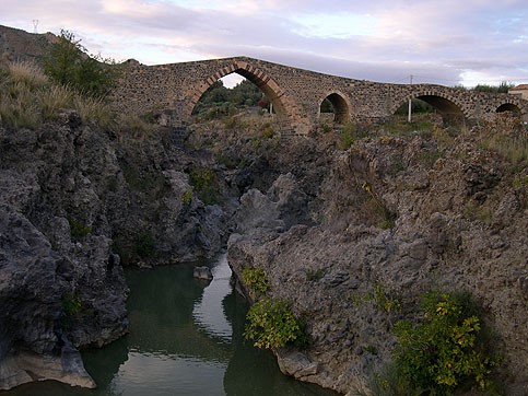
The Bridge of the Saracens is a bridge built in stone and dating from the ninth century on the river Simeto. It connects the territory of Adrano with that of Centuripe, through the step of Pecoraio, and to the detriment of the name it is a Norman building.
It is 4 kilometers from the city of Adrano: this is the Bridge of the Saracens remained in Europe. Built over the ruins of the point of Roman, in Arab-Gothic, allowing you to connect the two banks of the river Simeto. It had several reconstructions in the sixteenth and eighteenth centuries, and even in the recent 80 years.
The bridge originally was part of an important road that linked the city of Troina, first capital of the kingdom of Roger I of Hauteville, with Catania. After crossing the bridge the road ran along the Simeto downstream of the city of Adrano and Paterno. In fact, the dungeons of these cities and to Motta, along with the bridge, are historically and strategically linked: the road served by the bridge was controlled militarily by the aforementioned towers.
Il ponte scavalca un tratto delle forre laviche (conformazioni basaltiche) presenti in quella zona. Quella attuale è solo una parte dell’antica struttura,infatti solo l'arcata maggiore, centrale, ad arco acuto fanno parte del ponte originale. Le altre arcate, una più piccola a sesto acuto e un'altra a tutto sesto di probabile origine romana, andarono distrutte durante l'alluvione del 1948, e ricostruite in seguito, seppur diverse dalle originali.
City: Adrano
Coordinates start path: 14 ° 54'23,44 '' - 37 ° 42'58,63 ''
End path coordinates: 14 ° 54'19,02 '' - 37 ° 43'14,00 ''
Quote start path: 1322 m.s.m.
Quote end path: 1377 m.s.m.
Time path (round trip): 3h 20 '
Distance (return trip): 7.5 km
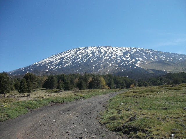
It starts from the Pinewood of Adrano, a forest of the south-western portion of Etna extended from 1400 to an altitude of 1700 meters above sea level and then come together, altitude 1871 m., At the Refuge Galvarina. The tourist site lies along the only road that climbs the slopes of the volcano from the town of Adrano, or the provincial 92-Adrano Mount St. Leo. The route is characterized by the typical flora of the low Etna, including both elements typical of the Mediterranean, as the broom that typical elements of mountain flora such as oaks and chestnut trees. Continuing the route previously mentioned, after passing alongside the homonymous cave, you wander towards the slopes of Mount Intraleo. Of particular interest is the cave Intraleo as it is one of the most impressive caves of Etna; It is located at an altitude of 1370 meters and is developed in a lava flow whose dating should go back to 1595.
 Mount Gallo - Refuge Galvarina
Municipality: Adrano
Coordinates beginning path: 14°54'23,44'' - 37°42'58,63''
Coordinates end path: 14°54'19,02'' - 37°43'14,00''
Quote start path: 1322 m.s.m.
Quote end path: 1377 m.s.m.
Time path (round trip): 3h 20'
Distance (round trip): 7.5 km
On the provincial Adrano-Mount St. Leo, after the area of the pine forest of Adrano, turn left along the road that leads to the car park where you access to the State forest. It starts with a large open space, called precisely plan Fair (1474 m.), On the slopes of Monte Gallo in whose vicinity are located: the caves of Monte Gallo, of Gallo White I and White Rooster II.
From this point you can admire the Mount Forno and Mount Head, and it is here that begins the real journey forest. On the path, initially flat, you can admire high brooms, pines, oaks, chestnut trees and various species of conifers and shrubs; It is also interesting to note that, over the course of the journey, you have the sequence of altitudinal vegetation typical of Etna. The route departs, then, in two sections: going to the right passes for Monte Albano, continuing to the left, instead, you come to the mountain Leporello.
Whether you head to Monte Monte Albano that Leporello, you get to the end of the refuge Galvarina (d. 1871), which is about 7 km from Piano Fair. The refuge Galvarina was renovated in 1991 and has a large cistern. A volcanic cone surrounded by many pine larch, located behind the hut, hit in the past the attention of Goethe during his trip to Sicily.

