")
")
Sicily Food
Botanical Gardens New Gussonea

The garden was established in 1979 through an agreement between the General Directorate of Forests of the Sicilian Region and the University of Catania. It named after the famous scholar of Sicilian flora, John Gussone, both to give continuity to a similar initiative that dates back to the beginning of the century due to Fridiano Cavara, who founded (1903) on the southern side of the botanical garden "Gussonea" whose business was short-lived.
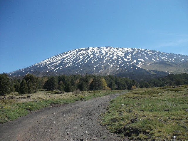
It differs from other botanical gardens (alpine gardens and mountains, botanical gardens), because of its location on an active volcano, in the middle of the Mediterranean region, but also for the structure and function that it was intended to give.
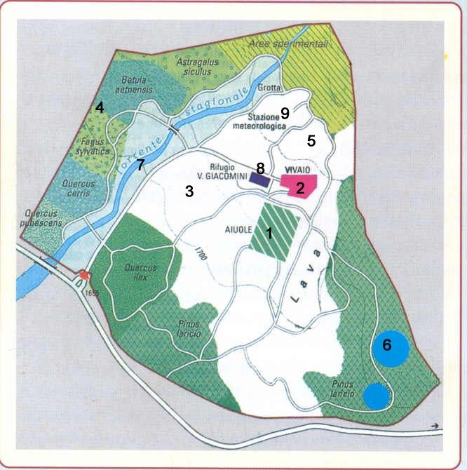
The target area covers over 10 hectares on the southern slopes of the volcano, between 1700 and 1750 m. It falls within the regional domain "John Saletti" and is located in an area where the forest vegetation represented by formations Pine larch, is pervaded by greenery on the floor of the high mountains (Astragaletum Sicilians).
To get to the garden you have to take an ice road to the land leading to the Rifugio Valerio Giacomini, logistics base for the staff; From this point they develop a series of trails that connect to the various sectors, among which we can point to those that are of particular interest:
- areas for the establishment of forest plant communities, characterized respectively by beech, birch Etna, oak, pine, larch, oak, holm oak;
- areas for major aspects of degradation of these plant communities;
- a surface lava for the study of the processes of the plant colonization, also for application purposes;
- a cavity in the lava rock to study the adaptations of plants to decrease the light intensity;
- a nursery for planting, cultivation and acclimatization of plants to stay put in the open;
- a weather station for recording climate data.
The garden has a significant role in environmental education both in structure and in function to it that we wanted to give: inside you can admire and learn about species and plant communities therefore among the most significant environmental Etna In his diversify in accordance with changes in climate and the lava substrate, Each visitor will be able to experience to understand melgar the plant world and its role in the wider environment of Etna.
![]() Black Mountain Zappini
Black Mountain Zappini
Difficulty ': Low
Altitude difference: 150 m
Maximum height: 1860m
Distance: 4.5 kilometers.
Travel time: 3 hours.
Possible free shuttle service offered by the City of Ragalna, in piazza Cisterna, reservations recommended.
The beginning of the trail is marked by Vetore Plan.
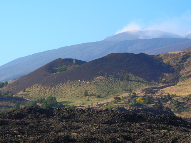
This path winding several points of interest: Ancient lava flows, hornito, larch forests, botanical garden, astrophysical observatory, caves of volcanic rock and lava cave.
This route is suitable for all ages, is characterized by a volcanic path, consisting of a dirt road on the right where you can see some ancient lava flows. In this trail you can see a suggestive "Hornito" (word of Spanish origin meaning "little oven") arisen from escaping certain amount of gas coming from the lava below.
Also through a larch forest, you will reach the botanical garden Etna "New Gussonea" peculiar not only being located on a volcanic mountain and filled the Mediterranean region, but also because it is intended to house only species and plant communities Etna (endemic) , such as birch, appeared presumably during the last glaciation and survived until today for having developed a natural system to adapt to the Sicilian climate. The excursion includes a visit to a cave in lava, that of "Santa Barbara."
Place: Territory of Randazzo and Maletto / Etna West on State Road 120 towards Randazzo-Maletto.
Journey time: 2 h
Length of the trail: 6 km (internal circuit).
Quote of origin and destination: Maletto 960 / lake 835 m.
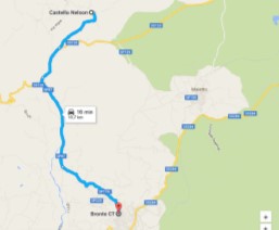
Starting from the Castle Nelson continue along State Road 120 towards Randazzo.
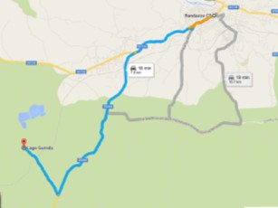
Along the way you will observe the plan of Santa Venera; in this country we were found the remains of a hut ellipsoidal Bronze Age and remains of a Roman wall in the fourth century. After a few kilometers a sign indicating the turn to get to Lake Gurrida.
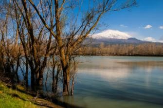
Lake Gurrida represents a unique element in the Etna park. It is the only wetland on the volcano and is a place where you can observe many species of migratory birds, especially in winter and spring. The lake is fed by the river seasonally Flascio. It is a river that over the centuries has been tributary alternately Simeto or Alcantara, until an eruption (in 1536) not barred definitively the road leading him to form the lake Gurrida. In the past they were made of the reclamation works, to prevent the area was at the mercy of the flooding of the river; It has therefore created a permanent reservoir (lake) and a surrounding area that is flooded in a controlled manner during the flooding of the river.
In this context one can also admire the rare aquatic plants like Junncus and Carex well as note the peculiarity of the lake, which is to be both a very special and unique "grape".
In fact, in the summer months and during the harvest, the lake is completely dried up, and in the winter the river water Flascio the cover allowing the vine to buy particular organoleptic qualities.
This unusual technique was introduced in the nineteenth century by a wine expert who worked at the Duchy of Nelson, and it seems to be able to give the wine indisputable and special qualities.
Place: Maniace / Etna West, Via Santa Maria di Maniace.
Type: Easy.
Distance: 13 Km from Bronte and 1 km (internal circuit).
Time required: a / r: 2 h.
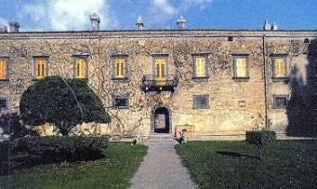
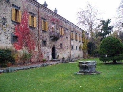
The Abbey of Santa Maria di Maniace (also called Duchy of Nelson, Nelson and Castle Maniace Duchy) is a building that is on the border between the towns of Bronte and Maniace. It was founded by Queen Margaret of Navarre, wife of William I of Sicily, in the twelfth century. It was donated in perpetual feud with the (15,000 hectares) in 1799 by King Ferdinand I of the Two Sicilies to the English Admiral Horatio Nelson out of gratitude that he had repressed the so-called Neapolitan Republic, saving his life and kingdom.
![]()
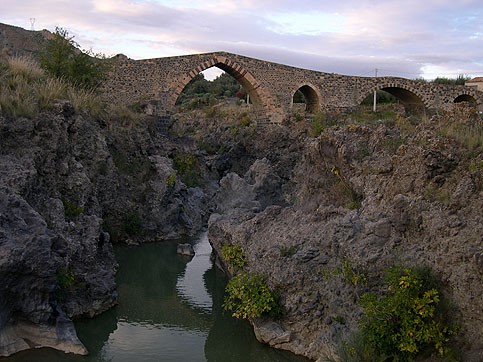
The Bridge of the Saracens is a bridge built in stone and dating from the ninth century on the river Simeto. It connects the territory of Adrano with that of Centuripe, through the step of Pecoraio, and to the detriment of the name it is a Norman building.
It is 4 kilometers from the city of Adrano: this is the Bridge of the Saracens remained in Europe. Built over the ruins of the point of Roman, in Arab-Gothic, allowing you to connect the two banks of the river Simeto. It had several reconstructions in the sixteenth and eighteenth centuries, and even in the recent 80 years.
The bridge originally was part of an important road that linked the city of Troina, first capital of the kingdom of Roger I of Hauteville, with Catania. After crossing the bridge the road ran along the Simeto downstream of the city of Adrano and Paterno. In fact, the dungeons of these cities and to Motta, along with the bridge, are historically and strategically linked: the road served by the bridge was controlled militarily by the aforementioned towers.
Il ponte scavalca un tratto delle forre laviche (conformazioni basaltiche) presenti in quella zona. Quella attuale è solo una parte dell’antica struttura,infatti solo l'arcata maggiore, centrale, ad arco acuto fanno parte del ponte originale. Le altre arcate, una più piccola a sesto acuto e un'altra a tutto sesto di probabile origine romana, andarono distrutte durante l'alluvione del 1948, e ricostruite in seguito, seppur diverse dalle originali.
City: Adrano
Coordinates start path: 14 ° 54'23,44 '' - 37 ° 42'58,63 ''
End path coordinates: 14 ° 54'19,02 '' - 37 ° 43'14,00 ''
Quote start path: 1322 m.s.m.
Quote end path: 1377 m.s.m.
Time path (round trip): 3h 20 '
Distance (return trip): 7.5 km
It starts from the Pinewood of Adrano, a forest of the south-western portion of Etna extended from 1400 to an altitude of 1700 meters above sea level and then come together, altitude 1871 m., At the Refuge Galvarina. The tourist site lies along the only road that climbs the slopes of the volcano from the town of Adrano, or the provincial 92-Adrano Mount St. Leo. The route is characterized by the typical flora of the low Etna, including both elements typical of the Mediterranean, as the broom that typical elements of mountain flora such as oaks and chestnut trees. Continuing the route previously mentioned, after passing alongside the homonymous cave, you wander towards the slopes of Mount Intraleo. Of particular interest is the cave Intraleo as it is one of the most impressive caves of Etna; It is located at an altitude of 1370 meters and is developed in a lava flow whose dating should go back to 1595.
Place: Biancavilla. Coordinates 14 ° 48'04 '' - 37 ° 42'00 ''
Track length: 0.1 km (one way).
Altitude at departure and arrival: 363/362 s.l.m.
Time required: a / r: 10 '(one-way).
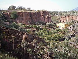
Coming in Biancavilla by state 284, at the junction for entering the city will turn heads a canyon ("Vallone Sumac") from the reddish walls of pyroclastic origin.
It is a lava deposit born about fifteen thousand years ago (Pleistocene), "Ignimbrite of Pallet-Montalto", formed by mudslides released by sudden shots of the eruptive activity, characterized by violent explosions, even with the sudden release of huge amounts of water.
In this area we find ashes, bombs and blocks firmly united among themselves testifying cone explosions quell'atinco volcano have been violent. You can also find fossils of trees and charred organic remains generic.
Mount Gallo - Refuge Galvarina
Municipality: Adrano
Coordinates beginning path: 14°54'23,44'' - 37°42'58,63''
Coordinates end path: 14°54'19,02'' - 37°43'14,00''
Quote start path: 1322 m.s.m.
Quote end path: 1377 m.s.m.
Time path (round trip): 3h 20'
Distance (round trip): 7.5 km
On the provincial Adrano-Mount St. Leo, after the area of the pine forest of Adrano, turn left along the road that leads to the car park where you access to the State forest. It starts with a large open space, called precisely plan Fair (1474 m.), On the slopes of Monte Gallo in whose vicinity are located: the caves of Monte Gallo, of Gallo White I and White Rooster II.
From this point you can admire the Mount Forno and Mount Head, and it is here that begins the real journey forest. On the path, initially flat, you can admire high brooms, pines, oaks, chestnut trees and various species of conifers and shrubs; It is also interesting to note that, over the course of the journey, you have the sequence of altitudinal vegetation typical of Etna. The route departs, then, in two sections: going to the right passes for Monte Albano, continuing to the left, instead, you come to the mountain Leporello.
Whether you head to Monte Monte Albano that Leporello, you get to the end of the refuge Galvarina (d. 1871), which is about 7 km from Piano Fair. The refuge Galvarina was renovated in 1991 and has a large cistern. A volcanic cone surrounded by many pine larch, located behind the hut, hit in the past the attention of Goethe during his trip to Sicily.
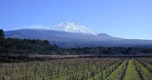
Massif Etna screw plays a leading role. L '"Homo Etneus" has enhanced soil rough and wild. Impressive works of terracing, walls paraterra Cleaning, mythical millstones, works of art of rural architecture unique in the world for dissemination and spectacular Etna, which have earned the inclusion in the list of UNESCO World Heritage Site. Viticulture different that Etna, originality environment for soil and climate and the distinction and excellence of the wines produced. Chemical and sensory characteristics due to the particular native grape varieties and Nerello Mascalese Carricante.
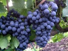
Ruby red color that with aging takes on light garnet reflections. Vinous with intense characteristic; dry, robust, full-bodied, with tannins and acidity that evokes the harshness of the landscape of Etna and the dark color of the volcanic sand. They are suitable for aging in wooden barrels, where they develop unexpected scents.
The rosé, kinder, ruby color, fruity, dry, odor of fermenting must;
white, straw yellow, with golden reflections, delicate cultivar Carricante (native), cultivated since time immemorial.
 Information:
Nature walk at the lake Gurrida
Lunch in a local agreement
Company visit to the cellar with tasting
Recommended period: all year
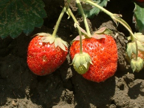
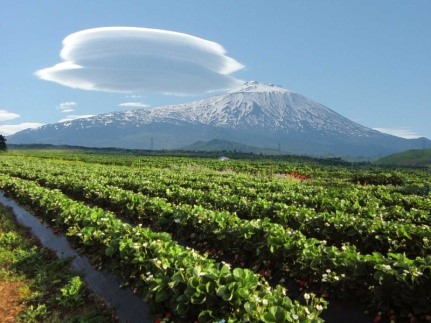
The strawberry production Maletto made famous in the world: taste a strawberry Maletto means to fill up a scent and taste that only these lands are able to infuse the red and pulpy fruit. Maletto is a small town in the province of Catania, located on the northern slopes of Etna between Bronte, Maniace and Randazzo a territory rich in history, rich in historic farmhouses of old tastes, a picturesque area rich in forests and soils sciarosi, virtually yet almost untouched. Since 1950 in this land they were planted the first fragoleti in lava soil certainly very fertile, so fertile that it was never necessary to use synthetic fertilizers. Then, when these lands began to be impoverished by chance were discovered several underground springs rich in minerals. The climate and the ground give these fruits a unique flavor. Taste a strawberry Maletto today means making a sensory experience the fruit is particularly red, fleshy, fragrant and sweet. There are three varieties of the cultivated strawberries Strawberry, Fragraria Vesca, widely used in confectionery, the Madame moutho a strawberry very big and juicy, and the flourishing allowing producers harvesting the fruit, eleven months a year.
The seedling of strawberry that is born spontaneously in the woods is transplanted open field without other artificial processes of maturation that can alter the organoleptic characteristics .This gives the Maletto strawberry extraordinary delicacy and fragrance. Today this product is present in the Italian and foreign fruit and vegetable markets and is highly sought after. Taste a strawberry Maletto means doing a taste that only these lands are able to infuse the red and pulpy fruit. Strawberries are particularly rich in ascorbic acid or vitamin C (it contains about 50% more than oranges). Contain fructose, a sugar low glycemic index, which has a relatively constant blood sugar and therefore can also be consumed in moderation by diabetics. Strawberry nutritional, laxative, diuretic, bactericidal, anti-uric, mineral and cleansing. It contains an active ingredient called acid metilsalicilico that exerts anti-rheumatic (practically the same active ingredient nell'aspirina). Strawberry also benefits from a potent thirst-quenching and refreshing due to its high water content.
information:
Visit the company
Tasting confectionery
Lunch in a local agreement
Visit the Duchy of Nelson

